
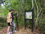
 Arriving at the Dauphin Island Audubon Bird Sanctuary, you’ll find parking and picnic areas as well as interpretive signage describing the habitats and birds you can find here and at the other stops along the Alabama Coastal Birding Trail. Explore the 1,000-foot handicap-accessible boardwalk from the parking lot to Gaillard Lake or the raised walkway through the Tupelo swamp. The sanctuary encompasses more than a mile of trails through a variety of intact habitats, including preserved maritime forest. » More Details
Travel Time from Previous Site: 5 minutes
Suggested Time at This Site: 2 hours
 The estuarium is an exciting educational facility highlighting the four key habitats of coastal Alabama: the Mobile Tensaw River Delta, Mobile Bay, the Barrier Islands and the Northern Gulf of Mexico. It includes the 10,000-square-foot exhibit hall and Living Marsh Boardwalk. This facility is a showcase of the plants, animals, and other natural resources found in the estuary and its surrounding marine habitats.
Through beautiful visuals and engaging interactive exhibits, the estuarium will leave you with a comprehensive understanding of the crucial link between the land and the sea—how watersheds, rivers and estuaries interact with Mobile Bay, the fourth largest estuary system in the United States.
This would be a good time to have lunch before continuing your trip. » More Details
Travel Time from Previous Site: 5 minutes
Suggested Time at This Site: 45 minutes
 The Mobile Bay Ferry connects the Mobile and Baldwin County segments of the byway and also offers travelers a unique connection with the waters of Mobile Bay. The 30-minute trip across the bay gives an up-close look at the waters and a chance to view the recreational and commercial maritime endeavors ever-active in these waters. » More Details
Travel Time from Previous Site: 20 minutes
Suggested Time at This Site: 2 hours
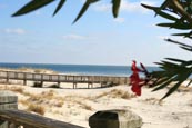
 Habitats of the refuge include beaches and sand dunes, scrub forest, fresh and salt water marshes, fresh water swamps, and uplands. Explore all of these along the three-mile Pine Beach Trail, which will lead you to the sugar-white sands of the area’s spectacular beaches. » More Details
Travel Time from Previous Site: 15 minutes
 After a full day of hiking the trails and exploring the waters, take time out to relax and let nature come to you. A refreshing night’s stay at any of a variety of gulf-front accommodations in Gulf Shores or Orange Beach allows you to sit back and enjoy the sounds of the surf, the smell of the salt air and the view of the sunset overlooking the gulf waters. For the more rustic types, camping and cabin accommodations are available with lake or lagoon views.
Travel Time from Previous Site: 10 minutes
Suggested Time at This Site: 2 hours
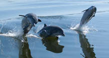 From one of the many marinas in Orange Beach visitors can enjoy a scenic back bay excursion aboard a charter cruise boat. Most have regularly scheduled morning and evening sightseeing trips and will schedule private trips upon reservations. This trip will offer an intimate view of the hundreds of acres of back bays along the byway and an interpretive overview of the birds and marine life you’ll see there. Resident wild bottlenose dolphin are a favorite sight on these tours.
Travel Time from Previous Site: 30 minutes
Suggested Time at This Site: 1 hour
 Weeks Bay is one of only 27 National Estuarine Research Reserves in the country and offers an exceptional opportunity for travelers to enjoy the educational materials of the interpretive center or take to the boardwalks and enjoy the environment firsthand.
Estuaries represent some of the most sensitive and ecologically important habitats on Earth. They provide sanctuary for many species of waterfowl, store nutrients for larval and juvenile marine life, and serve as breeding grounds for many desirable species of ocean fish. As one of the largest estuaries in the country, the Mobile Bay system is the foundation for the environmental beauty and diversity found along Alabama’s Coastal Connection. » More Details
Travel Time from Previous Site: 20 minutes
Suggested Time at This Site: 1 hour
 Enjoy lunch overlooking Mobile Bay at one of Fairhope’s local restaurants. Seafood is a specialty here, so savor the flavor of the bounty of the waters that are such an integral part of life here and all along the byway. Walks on Fairhope’s famous municipal pier provide spectacular views.
Since Fairhope is known as an artists’ colony, the art lover could take a leisurely visit to the Eastern Shore Art Gallery or the many local stores.
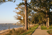 Work off your lunch by taking in the beautiful Eastern Shore of Mobile Bay. Take your choice of hiking or biking on the multi-use Eastern Shore Trail, where you can enjoy beautiful bay views and oak-canopied roadways. » More Details
There are plenty of accommodations options, on and off the bay, along the Eastern Shore.