
DAY 1
Suggested Time at This Site: Varies
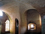 The role of Fort Gaines in the Battle of Mobile Bay is detailed in exhibits and signs throughout the fort. On a site where history spans three centuries, one can almost hear the sounds of cannons firing, echoing the distant past, while looking out over the gulf. Today the stories of the fort’s days in battle, and the soldiers encamped there, are brought to life daily. » More Details
Directions from previous place: Depart from the fort and turn right onto Bienville Boulevard. Then enter the boarding area for the Mobile Bay Ferry.
Distance from Previous Site: 0.5 miles
Travel Time from Previous Site: 2 minutes
Suggested Time at This Site: 45 minutes
Travel Time from Previous Site: 2 minutes
Suggested Time at This Site: 45 minutes
 The Mobile Bay Ferry connects the Mobile and Baldwin County segments of the byway and also offers travelers a unique connection with the waters of Mobile Bay. The 30-minute trip across the bay gives an up-close look at the waters and a chance to imagine the heat of the battle as Union and Confederate vessels fought for control of this significant passage. » More Details
[/fusion_toggle]
The Mobile Bay Ferry connects the Mobile and Baldwin County segments of the byway and also offers travelers a unique connection with the waters of Mobile Bay. The 30-minute trip across the bay gives an up-close look at the waters and a chance to imagine the heat of the battle as Union and Confederate vessels fought for control of this significant passage. » More Details
[/fusion_toggle]
Directions from previous place: Disembark from the Mobile Bay Ferry and turn right into the fort site.
Distance from Previous Site: 0.5 miles
Travel Time from Previous Site: 45 minutes
Travel Time from Previous Site: 45 minutes
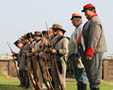 Since 1834 Fort Morgan has stood as guardian of Mobile Bay. On August 5, 1864, during the Civil War, the fort played a key role in the Battle of Mobile Bay before surrendering to Union forces after a two-week siege. The fort features a museum and a living history program, as well as candlelight tours during summer months. » More Details
Directions from previous place: Exit the fort site and continue 22 miles on SR-180 into Gulf Shores. Go straight on SR-135, and enter Gulf State Park. At the intersection of SR-182, turn left and travel approximately six miles to SR-161 in Orange Beach. Turn left onto SR-161 and continue until it intersects SR-180, and turn left. Travel approximately six miles then turn right onto the Foley Beach Express. Continue over the toll bridge and in approximately 6.5 miles turn right onto CR-20/Miflin Road until it makes a 90-degree turn and becomes CR-83. At the intersection of US-98 in Elberta, turn left and travel through the towns of Foley and Magnolia Springs. After crossing the Fish River bridge, turn right and go under the bridge to the public launch area.
Distance from Previous Site: 65 miles
Travel Time from Previous Site: 1.5 hours
Suggested Time at This Site: 20 minutes
Travel Time from Previous Site: 1.5 hours
Suggested Time at This Site: 20 minutes
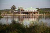 Troops gathered at the mouth of Fish River after traversing Weeks Bay from Fort Gaines on army transports and naval gunboats. Then they sailed up the meandering Fish River—dubbed by some as “the father of crooks”—on their way to Spanish Fort. Today the site is home to an environmental education center and a public boat launch. Look for the interpretive signs near the boardwalk.
Directions from previous place: Continue west on US-98 to the intersection of CR-98 (Scenic 98). Follow Scenic 98 through Fairhope and into Daphne. Turn left on College Avenue, which leads to the park.
Distance from Previous Site: 15 miles
Travel Time from Previous Site: 20 minutes
Suggested Time at this Site: 30 minutes
Travel Time from Previous Site: 20 minutes
Suggested Time at this Site: 30 minutes
 Now a municipal park in the City of Daphne, this site served as a U.S. Army supply depot in 1865. It is from this point that a flotilla crossed the bay on the quest to occupy the City of Mobile.
Directions from previous place: Return to CR-98 (Scenic 98). Turn left onto Scenic 98/Main Street, and continue left onto US-98. Just past the I-10 interchange, the Eastern Shore Overlook Welcome Center is on the left.
Distance from Previous Site: 5 miles
Travel Time from Previous Site: 10 minutes
Suggested Time at This Site: 30 minutes
Travel Time from Previous Site: 10 minutes
Suggested Time at This Site: 30 minutes
 In addition to the Eastern Shore Welcome Center here, there are interpretive signs which tell the stories of Fort McDermott and the 8th Iowa Line, crucial elements in the siege and battle at Spanish Fort.
Total Distance Traveled in Day 1: 86 miles